Leagrave is a former village and now a suburb of Luton in Bedfordshire in the northwest of the town. The area is roughly bounded by Vincent Road, Torquay Drive and High Street to the north, Roman Road and Stoneygate Road to the south, the M1 to the west, and Marsh Road and Leagrave Park to the east.
Due to its 35-minute connection by train from Leagrave station into London it is home to significant numbers of commuters, with almost two million using the train station each year. Leagrave station also has connections to Bedford in the north and Brighton in the south by Thameslink. Junctions 11 and 11a of the M1 are close at hand as well as Luton Airport.
The village of Leagrave was recorded in 1224 as Littegraue, intimating that its name means ‘Light-coloured, or lightly wooded, grove’. However, another source suggests its name originates from Lygegrove: “Lyge” being an old name for the River Lea. A place spelt as Lythtegrave (which may refer to Leagrave, since the prior of Dunstaple also features, and the county margination is Bedfordshire) appears in 1396.
The first settlement in the area was Waulud’s Bank which is a Neolithic D-shaped enclosure in Leagrave Park at the source of the River Lea and is now a protected monument. Waulud’s bank consists of a bank and external ditch of around 7 hectares with a turf revetted chalk and gravel bank (built from the excavated ditch material). The ditch itself is about 9 m wide and 2 m deep. Finds at the site have included neolithic Grooved Ware and flint arrow heads. It is a similar site to Durrington Walls and Marden and the site was later re-used in the Iron Age and during the Roman occupation.
The Icknield Way, a pre Roman road, passes though Leagrave. Local road names give away its location, ‘Roman Road’ runs from Oakley Road to Marsh Road. On the other side of Marsh Road as the road enters Limbury it continues as ‘Icknield Road’ where there is a gap before the road continues as Icknield Way.


The River Lea which flows through the area once formed one boundary of the Danelaw. Leagrave Marsh used to be a popular place for the Luton hatters on their (rare) days off and was, consequently, known as “Blockers’ Seaside”. The hatmaking industry originally relied on straw plaits, made by farmers’ wives, bought and collected by a “plaitman” and brought into the Luton hat factories to be made into straw hats. A new artwork has been unveiled in the area, reflecting on this former activity.
The manor of Leagrave was held by the Lucy family from 1305 to 1455. The Lucys gave their name to the neighbouring suburbs of Lewsey, Lewsey Farm, and Lewsey Park.
Leagrave station was built by the Midland Railway company in 1868 on its extension to St Pancras. The original Midland station buildings still exist, having been carefully restored in the 1980s.
In 1866 the villages of Leagrave and Limbury were formed into the ecclesiastical parish of ‘Holy Trinity, (Biscot)’. Thirty years later, in 1896 Leagrave civil parish was formed under the provisions of the ‘Local Government Act 1894‘, in the ecclesiastical parish of Limbury-cum-Biscot.
In 1914 Hewlett & Blondeau Limited, an aircraft manufacturing business, opened a factory at Leagrave called The Omnia Works. The company was managed by Hilda Hewlett who lived on site. During the First World War the factory produced more than 800 aircraft and employed up to 700 people. The business closed in 1920 and in 1926 the factory site was sold to Electrolux.
The area grew significantly in between the wars and in 1928 the parish was abolished when the boundaries of Luton were extended to include Leagrave, as well as Limbury and Stopsley. Further expansion of the area took place during the 1930s. Much of the housing stock of the area dates from the 1920s and 1930s and is typical of the era, with large bay-fronted semi-detached and terraced houses the typical housing built at this time. Some of the old farm names live on in the modern road names, Strangers Farm lends its name to the current Strangers Way, and Grange Avenue (Grange Road until the 1920s) takes its name from The Grange Farm.
Until the 1990s Electrolux was one of the larger employers in the area; however, much of the old factory site was sold off in the early 2000s for redevelopment into housing. The most recent development on the site was Saxon-Gate.
The current site of the McDonald’s restaurant on Marsh Road was the site of the Three Horseshoes pub, which was demolished in 1994. The roundabout next to McDonald’s takes its name from the old pub, with the old pub sign incorporated in the planting scheme. The Sugar Loaf pub was also located on the high street, but this has since been converted into a restaurant and then more recently renovated into flats.
Following Leagrave village becoming part of the larger town of Luton in 1928, many local roads were renamed to avoid confusion with existing Luton road names. For example, Oak Road became Oakley Road, Cumberland Avenue became Compton Avenue and Salisbury Road became Sarum Road (Sarum being the Roman name for Salisbury).
There is a parade of shops on High Street/Grange Avenue at the centre of Leagrave, as well as a busy commercial area on the border with Limbury on Marsh Road.
Electrolux has moved its UK headquarters back to the area, based in one of the old Omnia Works buildings on Oakley Road.
Leagrave is increasingly a commuter area with many people taking advantage of the 35-minute train journey time into London as well as motorway connections to London and to the North. This has led to many new developments of infill housing and apartment buildings.

Much of the land around the old Marsh Farmhouse (which gives its name to neighbouring Marsh Farm), as well as Leagrave Common is now part of Leagrave Park. The park provides contains a number of different areas including sports pitches, native woodland habitat, wildlife areas, river and wetland areas and links to the historic environment. It comprises a playing field of 59.34 acres with pavilion, play area, bowling green and car parking. The park also includes areas of County Wildlife designation, Leagrave Common and the Scheduled Monument, Waulud’s Bank a 4500-year-old Neolithic enclosure.

River Lee in Leagrave Marsh Only a few hundred metres from its source and the River Lee is already over 10 metres wide here. The confluence of Houghton Brook with the river is just up the watercourse on the left.

St Lukes Church, Leagrave, The largest church in the parish is St Lukes on Leagrave High Street, which was consecrated by the Bishop of Saint Albans in June 1956. It is a grade II listed building due largely to its frontage, and was designed by John Seely and Paul Paget.
Leagrave Methodist Church is also on Leagrave High Street. The first Methodist Church in Leagrave opened on 3 June 1824, and a gallery was added 5 years later in 1829. This Church was rebuilt in 1880.
Moorlands School and Nursery was founded in 1891. It was originally located in the town centre before moving to Dunstable Road. In 1958 the school had grown significantly and new premises were needed. The school relocated to Leagrave Hall (built in 1850), a former home of the Filmer family. In September 2011, Barnfield Moorlands Free School became a free school, the first such school in Luton and all of Bedfordshire, when it joined the Barnfield Federation in September 2012.
Leagrave is in the north of Luton, roughly 3.5 miles north of the town centre. Neighbouring areas are Hockwell Ring and Sundon Park to the north, Challney and Maidenhall to the south, Lewsey to the west, and Marsh Farm and Limbury to the east.
The source of the River Lea is in the area, which flows for 42 miles to join the Thames in East London.

Knapps Brook in Leagrave. The Lea crosses Leagrave Common and receives a number of tributaries including Knapps Brook, which joins from culverts under the railway embankment and Toddington Road, Lewsey Brook and Houghton Brook. Knapps Brook[20] is a combination of brooks from East End, Houghton Regis and from Lewsey Park. Leagrave is a flat area.
Leagrave has a Non-League football team Kent Athletic F.C. who play at Kent Athletic Park.
Since 2005 The Luton Youth Festival has taken place in Leagrave. The festival usually takes place in the grounds and building of St Luke’s Church and features a combination of stages, local performances and youth groups. It was described as ‘ one of the regions most exciting and unique events’ by The Luton News. The event is run by charity Leagrave Youth Work Action Group.
The Bedford to London railway line cuts a portion of Luton off from the rest of it, this scheme will add a new crossing under the track near Leagrave park. This scheme is a reserve scheme and as such may only be developed should one of the 79 chosen schemes not be able to be completed.
Leagrave is mostly within the Leagrave ward, although some parts are within the Limbury and Sundon Park wards. The Leagrave ward also includes Hockwell Ring and Tophill.
Leagrave ward is represented by Cllr Waheed Akbar (Labour), Cllr Sheila Roden (Labour) and Cllr Desline Stewart (Labour).
The ward forms part of the parliamentary constituency of Luton North, and the MP is Kelvin Hopkins. Leagrave is within the East of England.

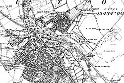
Map of Luton showing Leagrave location
An archaeological excavation was undertaken before the redevelopment of the Park Square campus, University of Bedfordshire. Records indicate that this area was the site of a castle built by Fulk de Breauté, an Anglo-Norman knight and favourite of King John, some time between 1216 and 1221. One Medieval document shows that the castle was surrounded by a moat, as there was a complaint that de Breauté had dammed the nearby river (presumably to help keep water in the moat) and caused serious flooding to crops and buildings belonging to the church. De Breauté was one of the most powerful men in the kingdom at the time, so was not overly worried by the complaints and allegedly said that he wished that the damage had been worse.
Although called a castle, this building was probably more like a fortified manor house, surrounded by a moat and earthen bank. In the interior would have been living quarters, a great hall, stables and outbuildings. The line of the moat and bank was still visible in the 19th century and seems to have been rectangular in shape. Previous excavations revealed the line of the moat on the northwest side and found traces of timber buildings.
Underneath the demolished Student Union were the remains of 19th century buildings and below these, well preserved medieval features: ditches, postholes and large pits. Finds included clothes pins and pottery dating to the 12–13th centuries confirming the activity was contemporary with Falks de Breauté’s castle.
The majority of the pottery were Hertfordshire Greyware which date to 12th – early 13th centuries. Hertfordshire Greyware is the local pottery of the period, and there were at least two pottery kilns making this close to Luton; at Hitchin and to the east of Toddington.
Waulud’s Bank archaeological excavations in 1953, 1971 and 1982 date the site to around 3000 BC, in the Neolithic period, although there was evidence of earlier mesolithic hunting and fishing activity in the immediate area.
The town grew strongly in the 19th century; in 1801 the population was 3,095.By 1850 it was over 10,000 and by 1901 it was almost 39,000. A railway connection was essential for this growth, and there was a long delay before this was provided. The London and Birmingham Railway (L&BR) had been built through Tring in 1838, and the Great Northern Railway was built through Hitchin in 1852, both bypassing Luton, the largest town in the area. A branch line connecting with the L&BR at Leighton Buzzard was proposed, but because of objections to release of land, the branch only reached Luton’s much smaller rival, Dunstable, in 1848. It was another ten years before the branch was extended to Bute Street Station, and the first train to Dunstable ran on 3 May 1858. The line was later extended to Welwyn and from 1860 direct trains to King’s Cross ran. The Midland Railway was extended from Bedford to St Pancras through Leagrave and Midland Road station and opened on 9 September 1867.
Luton had a gas supply in 1834, and the gas street lights were erected and the first town hall opened in 1847.
Newspaper printing arrived in the town in 1854, coincidentally the year the first public cemetery was opened. Following a cholera epidemic in 1848 Luton formed a water company and had a complete water and sewerage system by the late 1860s. The first covered market was built (the Plait Halls, now demolished) in 1869. Luton was made a borough in 1876 and the football club was founded in 1885 following the passing of a resolution at the Town Hall that the “Luton Town Club be formed”.


Luton is a large town, borough and unitary authority area of Bedfordshire, England. Luton and its near neighbours, Dunstable and Houghton Regis, form the Luton/Dunstable Urban Area with a population of about 258,000.
It is located 20 miles (30 km) east of Aylesbury, 14 miles (20 km) west of Stevenage, 30 miles (50 km) north-northwest of London, and 22 miles (40 km) South East of Milton Keynes.
Luton is home to League One team Luton Town Football Club, whose history includes several spells in the top flight of the English league as well as a Football League Cup triumph in 1988. They play at Kenilworth Road stadium, which has been their home since 1905.
London Luton Airport, opened in 1938, is one of England’s major airports. During the Second World War it doubled as an RAF base. The University of Bedfordshire is based in the town.
The Luton Carnival, which has traditionally been held on the Whitsun May bank holiday, is the largest one-day carnival in Europe. It has for the past two years been held on the Sunday instead. In 2012, it was moved to July to coincide with the Olympic Torch Relay and celebrations.
The town was for many years famous for hat-making, and was also home to a large Vauxhall Motors factory; the head office of Vauxhall Motors is still situated in the town. Car production at the plant began in 1905 and continued until 2002, where commercial vehicle production remains.


Luton has been hailed a property hotspot thanks to its status a key commuter town for those who work in London. With comparatively low house prices and close proximity to the capital, this bustling town in the county of Bedfordshire has a lot to offer. But just how much do you know about Luton?

Luton hosts the UK’s biggest one-day carnival, the Luton International Carnival. This colourful, cultural event features a wide variety of music, performance artists, and dancers that come together in a large Brazilian-style procession. It is traditionally held on the late May bank holiday.

Dating back to the 1700’s, hat-making was one of Luton’s biggest industries. Even the local football team, Luton Town FC, are nicknamed ‘The Hatters’! Although millinery isn’t the high profile trade it once was, there are still several small-scale businesses in the town still producing high quality hats.

The earliest evidence of settlements in the Luton area are Palaeolithic encampments at Round Green and Mixes Hill that date back around 250,000 years!

London Luton Airport is the fifth busiest in the UK and the fourth biggest of London’s six airports. One of the main employers in the town, the airport dates back to 1938 and was used by the RAF in WWII. They handle over 14,500,000 passengers a year and fly to 60 destinations across Europe, Northern Africa and Asia.

Yes, in the 1970s Campari ran an advert featuring the glamourous Lorraine Chase in which her response to the question “Were you truly wafted here from paradise?” was “Nah, Luton Airport.” This immortalized the town, with the quote becoming a notable pop culture reference.

According to data from LendInvest, Luton is one of the UK’s most profitable areas to be a landlord. With high rental yields of up to 6% and house prices rising 18.5% in 2015, the potential ROI for investors is certainly impressive. And thanks to an ever-growing population, demand has pushed average rents up by 10.4% since 2014 – the biggest in the UK!

Former Wisden Cricketer of the Year and two-time Ashes winner Monty Panasar is from Luton!
Modern Luton is fast becoming the first choice area for creative young professionals who commute to London for work, but want a place to live that reflects their culture and lifestyle. With the ongoing investment in the town, including projects such as Luton’s Cultural Quarter, it’s becoming an increasingly attractive prospect for investors too.
Early Luton
6th Century The Saxons conquer Bedfordshire
10th Century Luton has grown into a busy little town
1139-1154 A castle exists in Luton. It gives Castle Street its name.
1336 Luton is badly damaged by a fire
1645 A skirmish takes place in Luton during the Civil War
18th Century A straw hat making industry booms in Luton
1757 Luton Hoo is built
1797 A bridge is built over the River Lea
19th Century Luton
1801 The population of Luton is 3,095
1834 Luton gains gas light
1847 Luton Town Hall is built
1848 Luton is struck by cholera
1850 A Board of Health is formed in Luton
1854 Luton gains its first newspaper
1858 The railway reaches Luton
1865 Luton gains a piped water supply
1872 Luton gains its first hospital
1876 Luton is made a borough
1877 Luton Chamber of Commerce is founded
1885 Luton Town FC is founded
Modern Luton
1901 The population of Luton is 38,926
1904 The council purchases Wardown estate and makes it a park
1905 Vauxhall comes to Luton
1908 Trams begin running in Luton
1909 The first cinema in Luton opens
1919 Luton Town Hall is burned during a riot
1931 Wardown House is made a museum and art gallery
1932 Trams in Luton cease as buses have replaced them
1936 A new Town Hall is built in Luton
1937 A new Court House is built
1938 Luton Airport opens
1939 Luton and Dunstable Hospital opens
World War II In Luton 107 people are killed by German bombing
1962 A new Central Library is built
1960s Luton has a population of over 130,000
1972 The Arndale Centre is built
1991 Wigmore Park Shopping Centre is built
1997 Luton is made a Unitary Authority
1998 The Galaxy Leisure Centre is built
1999 Luton Airport Parkway Station is built
2002 Car production in Luton ends
2007 St Georges Square is redeveloped
Luton is a large town and is a borough of Bedfordshire with an estimated population of over 200,000 people. Luton town is situated on the River Lea and is located about 30 miles north-west of London. This has led Luton to be hailed as a property hotspot, as it is a key commuter town for those who work in London. Thanks to its comparative low house prices, Luton has a lot to offer you! Here are 5 amazing facts of Luton’s history:
The earliest evidence of settlements of the Luton area has been traced back to date over 250,000 years! Luton was founded in the 6th century during the reign of the Anglo Saxons who conquered Bedfordshire. This is believed to be where the name ‘Luton’ originated from, as the Saxons built a settlement called a ‘tun’ by the River Lea. ‘Lea’ is a Celtic word that translates to ‘bright river’, meaning Lea-Tun or Luton, which we call it today, means ‘a settlement by the bright river’.
In the 1700’s, Luton was famous for its hat-making, which became one of Luton’s largest industries. Founded in 1885, Luton Town Football Club has had several spells in the top flight of the English league. Thanks to Luton’s famous hat-making, the club is nicknamed ‘The Hatters’!
Today, people from across the UK and Internationally will be familiar with the Luton area for London Luton Airport. Luton Airport was opened in 1938 and is the fifth busiest airport in the UK, with it the fourth largest of the six London airports. To do this day, Luton Airport handles over 14 million passengers a year, flying them to 60 destinations around the world.
The Luton International Carnival is traditionally held on the day before the last Monday in May. On a public holiday, this event celebrates culture with a colourful carnival featuring wide varieties of music, performances and dancing in a Brazilian-style. This event is one you cannot miss!
To this day, The Vauxhall Factory, owned by Vauxhall Motors, is one of the oldest vehicle manufacturers in the Luton area. Many associate Luton with Vauxhall, but did you know about the airstrike during the Second World War? Vauxhall Motors contributed to the war by manufacturing tanks for Churchill’s British army. However, after failing to fully camouflage the tanks, the factory was a target of several air strikes from the Luftwaffe, Germany’s air force. Thankfully, the Luton area recovered quickly and in recent news, the Vauxhall factory will manufacture Vauxhall’s new Vivaro van that will safeguard jobs and create more employment.
Thank you for reading!
SAXON LUTON
Luton began when the Saxons conquered Bedfordshire in the 6th century. They created a farm or settlement called a tun by the river Lea. (Lea may be a Celtic word meaning bright river). By the 10th century, the little settlement of Lea tun had grown into a town. Luton would seem very small to us with a population of only several hundred.
Many of the people of Medieval Luton lived by farming, at least part time but there was a market in the town and it acted as a focal point for the surrounding villages. By the time of the Domesday Book (1086) ‘Loitone’ probably had a population of 750-800. Again it would seem tiny to us but by the standards of the time, Luton was a respectable size. Most villages only had populations of 100 or 150. Later in the Middle Ages, the population of Luton probably rose to around 1,500.
LUTON IN THE MIDDLE AGES
In the Middle Ages Luton had 6 watermills. One mill gave its name to Mill Street. In 1137 the Lord of the Manor built a new church. In 1139 he built a castle. This castle was demolished in 1154 but it gave its name to Castle Street.
In the late 12th century a ‘hospital’ where poor travelers could stay was built in Farley Hill. There was another hospital in Luton, this one for sick people. It was dedicated to the Virgin Mary and Mary Magdalene.
As well as a market Medieval Luton had a fair. A fair was like a market but it was held only once a year. Luton’s fair was held for 1 week in August and it would attract sellers from as far away as London. After 1338 Luton had a second fair in October.
In 1336 there was a great fire in Luton which destroyed much of the town. Fire was a constant danger in those days because most buildings were made of wood with thatched roofs. However, if they burned they could be easily rebuilt. Luton soon recovered from the disaster.
LUTON 1500-1800
For centuries Luton continued to be a quiet market town serving the surrounding countryside. In the 16th century a brick making industry grew up in Luton. Until then most houses were of wood but in the 16th century many people re-built their houses in brick. In the 17th century a straw hat making industry began. In the 18th century it came to dominate Luton.
During the civil wars of the 17th century there were 2 skirmishes in Luton. The first occurred in 1645 when some royalists entered Luton and demanded money from the townspeople. Parliamentary soldiers came and in the ensuing fight 4 royalists were killed and 22 were captured. A second skirmish occurred in 1648 when a royalist army passed through Luton. A group of stragglers were caught by parliamentary soldiers in an inn on the corner of Bridge Street. Most of the royalists escaped but 9 were killed.
In the 18th century Luton continued to be an agricultural market town serving the local villages. Hatmaking was its only important industry. In Georgian Luton there were the same craftsmen you found in any market town such as brewers, bakers, butchers, carpenters and blacksmiths. In the early 18th century a writer said: ‘It has a market house and a large Monday market for corn with which this area much abounds’.
Luton Hoo was built in 1757 for the 3rd Earl of Bute. It was designed by the architect Robert Adam (1728-1791). However it was largely rebuilt after a fire in 1843.
For centuries there had been a ford across the Lea. In 1797 a bridge was built and Bridge Street was created.
LUTON IN THE 19th CENTURY
Luton grew rapidly in the 19th century. In 1801 the population was 3,095. By the standards of the time Luton was a fair sized market town. By 1851 the population of Luton had exceeded 10,000 and it continued to boom. By 1901 it had reached 38,926 more than 10 times the 1801 level.
The straw hat making industry continued to dominate Luton although some felt hats were made after 1877.
There were many improvements to Luton during this century. From 1834 Luton had gas light. In 1847 a Town Hall was built. The first in Luton newspaper began publication in 1854. The same year the first cemeteries were opened (as the churchyards were becoming overcrowded).
Like the rest of the country Luton suffered an epidemic of cholera in 1848. However conditions in Victorian Luton gradually improved. In 1850 a Board of Health was formed and they set about building sewers. A water company was formed in 1865 and by 1870 the whole town had a piped water supply. Meanwhile the railway reached Luton in 1858.
The covered market was built in 1869 as a plait hall where plait could be bought and sold. Then in 1872 Luton gained its first hospital when a cottage hospital was built. The same year the first swimming baths were built.
Luton was made a borough in 1876 and Luton Chamber of Commerce was formed in 1877. Luton Town FC was formed in 1885.
LUTON IN THE 20th CENTURY
During the 20th century the hat making industry, which had dominated Luton for so long went into decline but new industries came to Luton. One of these was engineering. Vauxhall came to the town in 1905. Soon Luton became known for car manufacturing. In the early 20th century gas cookers and meters were also made in Luton as well as ball bearings. A chemicals industry also began in Luton in the early 20th century.
Even during the depression of the 1930s Luton was a prosperous town and suffered less unemployment than many towns thanks to its new industries.
Luton grew rapidly in the 20th century. It had a population of about 50,000 in 1914 but by the 1960s it had grown to over 130,000.
Conditions in Luton improved in the 20th century. In 1908 trams began running in the streets but in the 1920s they were superseded by buses. The last trams ran in Luton in 1932. The first cinema in Luton opened in 1909. Luton airport opened in 1938.
In 1904 the council purchased Wardown estate and made it a park. Wardown house became a museum and art gallery in 1931. In 1919 the Town Hall was burned during a riot. A new Town Hall was built in 1936.
Also in the 1920s and 1930s the council set about demolishing the worst slums in Luton and they built the first council houses. A New Court House was built in 1937.
The boundaries of Luton were extended in 1928 and 1933 to include Leagrave, Limbury and Stopsley. Luton and Dunstable hospital opened in 1939.
Luton was bombed during the Second World War. Altogether 107 people were killed by German bombing and over 1,500 houses were destroyed or damaged. After the war Luton council had to replace these and also demolish many remaining slums. Many new council houses were built to replace them. Estates were built at Farley Hill, Stopsley, Limbury and Leagrave. Meanwhile the M1 was built in 1959.
A new central library was built in Luton in 1962 and the Arndale Centre was built in 1972. Wigmore Park Shopping Centre was built in 1991.
In 1997 Luton was made a unitary authority and in 1998 The Galaxy Leisure Complex opened. In 1999 a new railway station Luton Airport Parkway was built. So was a new passenger terminal at the airport.
LUTON IN THE 21st CENTURY
Car production ended in Luton in 2002. It was the end of an era for Luton although the town continues to prosper. In 2007 St Georges Square was redeveloped. Today the population of Luton is 211,000.
The sari is the standard garb of the women of the sub-continent. It creates a mystery and exudes sex appeal.
It must be noted that a multitude of religions, clans and tribes form part of the Indian union. But the one dress that is universal is the sari. The sari is a long wrap that is worn around the hips and extends to the ankles. Women of the sub continent will wear a blouse that will add to the luster of the sari.
The sari proper
The sari extends to 5 or 6 yards and comes in vibrant colors and designs. In addition sari’s will be made of a variety of materials ranging from cottons to silk. Some of the sari’s will be embroidered with intricate desins that could make use of gold thread as well. The sari thus can be a costly item as well. Some of the sari’s can set you back by Rs 5 Lakh.
Wearing a sari
There are many methods to tie the sari. Tt is usually draped around the waist with a petticoat as an anchor. It has a number of folds and wearing a sari is an art by itself. The sari can be worn in a way that the midriff is bare and in some cases, it can be tied low so as to add to the allure of the wearer. When worn with a blouse which can be sleeveless or backless the sex appeal of the woman is greatly enhanced. Many western men have told me that seeing a lovely woman in sari is a matter of great fantasy for them, as it creates a mystery of the woman by revealing a little and promising a lot.
Sari and sex appeal
Some of the Indian women will tie the sari in a way that the navel is visible.They will embellish the navel with a jewel as well. They will wear a low cut blouse that may be backless. This dress creates a great degree of sex appeal and is sure to fire the imagination of a man. One only has to look at the present day heart throb, the film actor Deepika Padakune in a sari to realise the potential it generates in terms of sex appeal.
Sari and Types
Some of the tribal women in the east will wear a sari without a blouse. The eastern women will also wear a shorter sari. Maharashtrian women will wear a 9 yards sari which divides the legs, enhancing the sex appeal to a tremendous extant. The sari is a dress that has been in vogue for thousands of years and is distinctive of the sub -continent.

Whats On In Ipswich & Things To Do In Ipswich thought idea innovation things to do in ipswich Creating Your Success: Stoking Your Creativity Self Improvement Self Improvement
When I signed up for toastmaster’s, I brought all my passion and zeal to every speech. I was on fire. A year and a half later, my steam has been reduced to a mere trickle of conviction. I have trouble winning contests. I’ve embarrassed myself when I tried taking on the humor role. And my drive to help others build success has taken a long road trip.
When I was a child, one of my aunt’s called me stupid. “Stupid.” That word rang in my ears loud and clear. My high school report cards all included “underachieves” No matter what I did or what I tried, I could not win those gold ribbons given out every quarter to the best students. So I gave up trying.
So what can you do to fan the flames of your creativity when the well has run dry. Let’s take a look at several suggestions.
I’m Barbara Altman
Raised in an alcoholic home, I became depressed and riddled with anxiety at an early age. In an effort to build a good life. Over the years, I have dealt with depression in a variety of ways, from counseling to alternative and traditional healing modalities. One of the purposes in my life is to convey hope to those who have suffered from depression and I hope to do this in my writings and in speaking engagements.
Author of “Recovering From Depression, Anxiety, and Psychosis,” formerly called “Cry Depression,”…